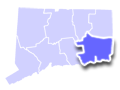
With hundreds of lakes, ponds, and rivers and ocean shoreline, New London County Connecticut is a boaters’ paradise. Summer residents usually get their boats in the water by June and enjoy the season until late October. Find boat launches and public boat ramps in each county of Connecticut. Use the map below to find CT boat launches areas, lakes and water access near your destination or location.
To feature your Connecticut marina or boat business, please contact us. Learn more about advertising in CTLiving.com.
|
New London County CT Boating Areas Marinas & Boat Launches
|

Preston
Amos Lake Boat Launch
Type: Trailered
Season: Year round
Directions: Turn east onto narrow road off Route 164 approximately 1.5 miles south of junction with Route 165.
Lake Area: 113 Acres
Regulations: 8 MPH limit, no water-skiing except for period June 15 to first Sunday after Labor Day, when speeds in excess of 8 MPH and water-skiing are permitted between 11 am and 6 pm.
Docks: None
Toilets: Chemical (Seasonal)
Parking Spaces: 25
Parking Surface: Recycled Pavement
Access Road Surface: Paved
Ramp Surface: Concrete Plank
ADA Accessible: No
North Stonington
Anderson Pond Boat Launch
Type: Car Top/Carry-In
Season: Year round
Directions: Access road west off Route 201.
Lake Area: 56.6 Acres
Regulations: None
Docks: None
Toilets: None
Parking Spaces: 8
Parking Surface: Paved
Access Road Surface: Paved
Ramp Surface: Paved
ADA Accessible: No
Preston
Avery Pond Boat Launch
Type: Trailered
Season: Year round
Directions: Turn east onto Lynn Drive off Route 164, continue straight ahead on narrow dirt road to launch.
Lake Area: 36 Acres
Regulations: 8 MPH limit, no water-skiing.
Docks: None
Toilets: None
Parking Spaces: 10
Parking Surface: Recycled Pavement/Grass
Access Road Surface: Recycled Pavement
Ramp Surface: Paved
ADA Accessible: No
Colchester
Babcock Pond Boat Launch
Type: Car Top/Carry-In
Season: Year round
Directions: Route 16 east of intersection with Route 149. Access is on the south side of Route 16 at Wildlife Observation Area.
Lake Area: 119 Acres
Regulations: 8 MPH limit, no water skiing.
Docks: None
Toilets: None
Parking Spaces: 5
Parking Surface: Dirt
Access Road Surface: Dirt
Ramp Surface: Dirt
ADA Accessible: No
Stonington
Barn Island Boat Launch
Type: Trailered
Season: Year round
Directions: Located at Barn Island Wildlife Area. Turn southeast off Route 1 at Greenhaven Road then south on Palmer Neck Road approximately 1.5 miles to end.
Regulations: None
Docks: Floating Wood (Seasonal)
Toilets: Chemical (Seasonal)
Parking Spaces: 60
Parking Surface: Paved
Access Road Surface: Paved
Ramp Surface: Concrete Slab
ADA Accessible: Yes
Groton
Bayberry Lane Boat Launch
Type: Trailered
Season: Year round
Directions: I-95, Exit 87, Route 349 (Clarence B. Sharp Highway) which becomes Shennecossett Road. Follow this road south, then left onto Bayberry Lane.
Regulations: None
Docks: Fixed Wood
Toilets: Chemical (Seasonal)
Parking Spaces: 30
Parking Surface: Paved/Grass
Access Road Surface: Paved
Ramp Surface: Concrete Plank
ADA Accessible: No
Additional Info: Very crowded
Voluntown
Beach Pond Boat Launch
Type: Trailered
Season: Year round
Directions: On north side of pond. Route 165, north on Forge Hill Road, right on North Shore Road to the launch.
Lake Area: 393.3 Acres
Regulations: No water-skiing within 800 feet of the dam.
Docks: None
Toilets: Chemical (Seasonal)
Parking Spaces: 25
Parking Surface: Paved
Access Road Surface: Paved
Ramp Surface: Concrete Plank
ADA Accessible: No
Additional Info: Pachaug State Forest
Voluntown
Beachdale Pond Boat Launch
Type: Trailered
Season: Year round
Directions: East side of Route 49, one mile north of Route 138 and Route 165 junction.
Lake Area: 45.9 Acres
Regulations: 8 MPH limit, no water-skiing.
Docks: None
Toilets: None
Parking Spaces: 20
Parking Surface: Dirt
Access Road Surface: Paved
Ramp Surface: Paved
ADA Accessible: No
Additional Info: Pachaug State Forest
North Stonington
Billings Lake Boat Launch
Type: Trailered
Season: Year round
Directions: Route 201, turn east onto Billings Lake Road.
Lake Area: 97.4 Acres
Regulations: None
Docks: None
Toilets: None
Parking Spaces: 6
Parking Surface: Dirt
Access Road Surface: Gravel
Ramp Surface: Concrete Plank
ADA Accessible: No
Additional Info: Pachaug State Forest
Groton
Bluff Point Boat Launch
Type: Car Top/Carry-In
Season: Year round
Directions: Route 1, south on Depot Road, go under train trestle at the end. Launch is at the end of the road to the west of the park entrance.
Regulations: None
Docks: None
Toilets: Composting (Year Round)
Parking Spaces: 40
Parking Surface: Dirt
Access Road Surface: Gravel
Ramp Surface: Dirt
ADA Accessible: No
Additional Info: Bluff Point State Park
Waterford
Dock Road Boat Launch
Type: Trailered
Season: Year round
Directions: Located on Jordan Cove at Pleasure Beach. Route 213, south on Goshen Road, launch is straight ahead.
Regulations: None
Docks: None
Toilets: Chemical (Year Round)
Parking Spaces: 45
Parking Surface: Gravel
Access Road Surface: Paved
Ramp Surface: Concrete Slab
ADA Accessible: No
Additional Info: Very crowded on weekends.
East Lyme
Dodge Pond Boat Launch
Type: Trailered
Season: Year round
Directions: Route 161, west on Hope Street, to north on Lake Avenue and Lake Avenue Extension.
Lake Area: 34.3 Acres
Regulations: Use of all motors prohibited.
Docks: None
Toilets: None
Parking Spaces: 30
Parking Surface: Grass
Access Road Surface: Paved
Ramp Surface: Dirt
ADA Accessible: No
Additional Info: Shallow pond.
Old Lyme
Four Mile River Boat Launch
Type: Trailered
Season: Year round
Directions: Located on the west side of Four Mile River. Route 156, east on Oakridge Drive, first right to launch area.
Toilets: Chemical (Seasonal)
Parking Spaces: 55
Parking Surface: Recycled Pavement
Access Road Surface: Recycled Pavement
Ramp Surface: Paved
ADA Accessible: No
Additional Info: Shallow launch conditions at low tide; clearance problem at high tide.
Salem
Gardner Lake Boat Launch
Type: Trailered
Season: Year round
Directions: Located east off Route 354 in Salem just north of Route 82.
Lake Area: 529 Acres
Regulations: 6 MPH limit from sunset to 8 am.
Docks: None
Toilets: Chemical (Seasonal)
Parking Spaces: 50
Parking Surface: Dirt
Access Road Surface: Paved
Ramp Surface: Concrete Plank
ADA Accessible: No
Griswold
Glasgo Pond Boat Launch
Type: Trailered
Season: Year round
Directions: Route 201, east on Hillview Heights, bear right to launch.
Lake Area: 168 Acres
Regulations: None
Docks: None
Toilets: None
Parking Spaces: 20
Parking Surface: Dirt/Grass
Access Road Surface: Gravel
Ramp Surface: Paved
ADA Accessible: No
East Lyme
Gorton Pond Boat Launch
Type: Trailered
Season: Year round
Directions: Route 161, west on Roxbury Road, right onto Kevin Road, launch is on the right.
Lake Area: 52.4 Acres
Regulatory Requirements: 8 MPH, no water-skiing. Jet skis, wetbikes, and similar vessels prohibited.
Docks: None
Toilets: Chemical (Seasonal)
Parking Spaces: 15
Parking Surface: Dirt
Access Road Surface: Paved
Ramp Surface: Concrete Plank
ADA Accessible: No
Additional Info: None
Old Lyme
Great Island Boat Launch
Type: Trailered
Season: Year round
Directions: Route 156, south to end of Smith Neck Road and Great Island Wildlife Area.
Docks: None
Toilets: Chemical (Seasonal)
Parking Spaces: 35
Parking Surface: Gravel
Access Road Surface: Paved
Ramp Surface: Paved
ADA Accessible: No
Additional Info: Shallow at low tide.
Voluntown
Green Falls Reservoir Boat Launch
Type: Car Top/Carry-In
Season: Open from the Friday before the third Saturday in April through December 30.
Directions: Route 138, take access road south to Green Falls State Park. Follow signs to launch.
Lake Area: 48.2 Acres
Regulations: Use of internal combustion engines prohibited.
Docks: None
Toilets: None
Parking Spaces: 6
Parking Surface: Dirt
Access Road Surface: Gravel
Ramp Surface: Gravel
ADA Accessible: No
Additional Info: Pachaug State Forest
Lyme
Hadlyme Ferry Boat Launch
(Connecticut River)
Type: Car Top/Carry-In
Season: Year round
Directions: In Hadlyme, just north off Route 148, adjacent to the Hadlyme Ferry.
Docks: None
Toilets: Pit (Year Round)
Parking Spaces: 10
Parking Surface: Dirt
Access Road Surface: Dirt
Ramp Surface: Dirt
ADA Accessible: No
Additional Info: Gillette Castle State Park
Griswold
Hopeville Pond Boat Launch
Type: Trailered
Season: Open from the Friday before the third Saturday in April through November, 8 am to sunset.
Directions: I-395, Exit 86, south on Route 201, right into Hopeville Pond State Park.
Lake Area: 137 Acres
Regulations: 8 MPH limit, no water-skiing.
Docks: None
Toilets: Flush (Seasonal)
Parking Spaces: 20
Parking Surface: Paved
Access Road Surface: Paved
Ramp Surface: Paved
ADA Accessible: No
Additional Info: Hopeville Pond State Park
Salem
Horse Pond Boat Launch
Type: Car Top/Carry-In
Season: Year round
Directions: Off west side of Route 85, between Chesterfield and Salem Four Corners.
Lake Area: 13.2 Acres
Regulations: Use of internal combustion engines prohibited.
Docks: None
Toilets: None
Parking Spaces: 10
Parking Surface: Dirt
Access Road Surface: Dirt
Ramp Surface: Dirt
ADA Accessible: No
Groton
KE Streeter Boat Launch
Type: Trailer
Season: Year round
Directions: I-95 South, Exit 86, straight onto Kings Highway, bear right onto Bridge Street, turn right onto Fairview Avenue. I-95 North, Exit 85, Thames Street exit. Bear right off the exit onto Bridge Street. Take next right onto Fairview Avenue. Launch is on the left.
Regulations: On the Thames River, 6 MPH limit within 200 feet of any dock, pier or wharf. Use of a vessel under power prohibited within 200 feet of a bathing beach or area or bathing raft or float in New London. Dead slow speed permitted through entrance to Alewife Cove and to moorings in New London. No boats within 350 feet of bathing beach.
Docks: Floating Wood
Toilets: Chemical (Seasonal)
Parking Spaces: 25
Parking Surface: Paved/Dirt
Access Road Surface: Paved
Ramp Surface: Concrete Slab
ADA Accessible: Yes
North Stonington
Lake of Isles Boat Launch
Type: Trailered
Season: Year round
Directions: East off Route 2, north on Watson Road onto Lake of Isles Road.
Lake Area: 88.7 Acres
Regulations: 8 MPH limit
Docks: Fixed Wood
Toilets: Chemical (Seasonal)
Parking Spaces: 10
Parking Surface: Gravel
Access Road Surface: Gravel
Ramp Surface: Concrete Slab
ADA Accessible: Yes
Additional Info: None
Ledyard
Lantern Hill Pond Boat Launch
Type: Trailered
Season: Year round
Directions: Route 214, south on Lantern Hill Road, launch on left.
Lake Area: 23.1 Acres
Regulations: None
Docks: None
Toilets: None
Parking Spaces: 6
Parking Surface: Recycled Pavement
Access Road Surface: Recycled Pavement
Ramp Surface: Recycled Pavement
ADA Accessible: No
Additional Info: Approach to ramp is difficult.
Old Lyme
Lieutenant River Boat Launch
Type: Car Top/Carry-In
Season: Year round
Directions: Located on the west side of Route 156, south of Ferry Road.
Regulations: None
Docks: None
Toilets: Chemical (Seasonal)
Parking Spaces: 3
Parking Surface: Dirt
Access Road Surface: Paved
Ramp Surface: Dirt
ADA Accessible: No
North Stonington
Long Pond Boat Launch
Type: Trailered
Season: Year round
Directions: Route 214, south on Lantern Hill Road. Access is on the right.
Lake Area: 109 Acres
Regulations: 5 MPH limit, no water-skiing.
Docks: None
Toilets: Chemical (Seasonal)
Parking Spaces: 35
Parking Surface: Gravel
Access Road Surface: Paved
Ramp Surface: Concrete Plank
ADA Accessible: No
Groton
Mystic River Boat Launch
Type: Car Top/Carry-In
Season: Year round
Directions: I-95, exit 89. Go south on Allen Street, then take your first left onto Sandy Hollow Road. At the end, turn left onto High Street. Take next right onto Bindloss Road and at the end turn left onto River Road. Launch is on the right on the west bank of the Mystic River, just north of I-95.
Regulations: No vessel, propelled by power, shall move at greater than 6 mph limit when approaching or passing, and while within two hundred feet of any wharf on either side of Mystic River between its mouth and Noank beacon and the most northerly channel buoy north of the Marine Historical Association.
Docks: None
Toilets: None
Parking Spaces: 8
Parking Surface: Dirt
Access Road Surface: Dirt
Ramp Surface: Dirt
ADA Accessible: No
Waterford
Niantic River Boat Launch
Type: Trailered
Season: Year round
Directions: Located approximately 0.25 mile northeast of Route 156 bridge across Niantic River in Waterford.
Regulations: None
Docks: Floating Wood
Toilets: Chemical (Year Round)
Parking Spaces: 100
Parking Surface: Paved
Access Road Surface: Paved
Ramp Surface: Concrete Slab
ADA Accessible: Yes
Lyme
Norwich Pond Boat Launch
Type: Trailered
Season: Year round
Directions: Route 156 north 3.8 miles from I-95, turn east onto access road into Nehantic State Forest.
Lake Area: 30 Acres
Regulations: Operation of motorboats prohibited.
Docks: None
Toilets: Pit (Year Round)
Parking Spaces: 9
Parking Surface: Gravel
Access Road Surface: Gravel
Ramp Surface: Paved
ADA Accessible: No
Additional Info: Nehantic State Forest
Griswold
Pachaug Pond Boat Launch
Type: Trailered
Season: Year round
Directions: At north end of pond, south off Route 138.
Lake Area: 841 Acres
Regulations: No water-skiing within 1000 feet of dam.
Docks: None
Toilets: Chemical (Seasonal)
Parking Spaces: 40
Parking Surface: Recycled Pavement
Access Road Surface: Paved/Gravel
Ramp Surface: Concrete Slab
ADA Accessible: No
Additional Info: Pachaug State Forest
East Lyme
Pattagansett Lake Boat Launch
Type: Trailered
Season: Year round
Directions: On Route 1, one mile west of junction with Route 1 and Route 161. Launch is to the north.
Lake Area: 128 Acres
Regulations: 8 MPH limit, no water-skiing except for the period of June 15 to first Sunday after Labor Day, when speeds in excess of 8 MPH and water-skiing are permitted between 11 am and 6 pm.
Docks: Floating Wood (Seasonal)
Toilets: Chemical (Seasonal)
Parking Spaces: 15
Parking Surface: Gravel
Access Road Surface: Paved
Ramp Surface: Concrete Slab
ADA Accessible: No
Colchester
Pickerel Lake Boat Launch
Type: Trailered
Season: Year round
Directions: At north end of the pond. Route 16 to junction of Route 149. Turn south on Route 149. Go west about 1.5 miles on Pickerel Lake Road.
Lake Area: 82.2 Acres
Regulations: 8 MPH limit, no water-skiing except for the period of June 15 to first Sunday after Labor Day, when speeds in excess of 8 MPH and water-skiing are permitted between 11 am and 6 pm.
Docks: None
Toilets: None
Parking Spaces: 10
Parking Surface: Paved
Access Road Surface: Dirt
Ramp Surface: Concrete Slab
ADA Accessible: No
East Lyme
Powers Lake Boat Launch
Type: Trailered
Season: Year round
Directions: Route 1, north on Upper Pattagansett Road, bear right onto Whistletown Road. Launch is on the right.
Lake Area: 144 Acres
Regulations: 8 MPH limit, no water-skiing.
Docks: None
Toilets: None
Parking Spaces: 20
Parking Surface: Dirt
Access Road Surface: Dirt
Ramp Surface: Dirt
ADA Accessible: No
Old Lyme
Rogers Lake Boat Launch
Type: Trailered
Season: Year round
Directions: Turn north off Route 1 onto Grassy Hill Road and travel approximately 1 mile. Launch is on the left.
Lake Area: 260 Acres
Regulations: Marine heads are prohibited. Boats propelled by airplane propeller, fan, or ducted fan are prohibited. Parasails are prohibited. Maximum of two water-skiers per boat. Personal watercraft operation permitted from 10 am to 6 pm Monday through Friday and 10 am to 7 pm Saturday and Sunday. Engines limited to 135 HP maximum. Motor powered craft prohibited beyond sign in cove at northwest end of lake. Boat traffic to proceed in southerly direction only on west side of Picnic Island, southwesterly direction only in excess of steerage way between Picnic Island and Whale Island, counterclockwise pattern throughout lake when in excess of steerage way speed. Speed limits: year-round, sunset to 10 am, 6 MPH: steerage way with no wake in cove by Hains Park and in boat launch channel.
Docks: None
Toilets: Chemical (Seasonal)
Parking Spaces: 20
Parking Surface: Gravel
Access Road Surface: Paved
Ramp Surface: Concrete Plank
ADA Accessible: No
Ledyard
Stoddard Hill Boat Launch
Type: Car Top/Carry-In
Season: Year round
Directions: In Stoddard Hill State Park. West side of Route 12 in Ledyard. East side of Thames River.
Regulations: On the Thames River, 6 MPH limit within 200 feet of any dock, pier or wharf. Use of a vessel under power prohibited within 200 feet of a bathing beach or area or bathing raft or float in New London. Dead slow speed permitted through entrance to Alewife Cove and to moorings in New London. No boats within 350 feet of bathing beach.
Docks: None
Toilets: None
Parking Spaces: 20
Parking Surface: Paved
Access Road Surface: Paved
Ramp Surface: Recycled Pavement
ADA Accessible: No
Norwich
Thames River Boat Launch
Type: Trailered
Season: Year round
Directions: I-95 North, Exit 84, left at end onto Williams Street. Turn east onto State Pier Road. Launch is at end under I-95 bridge. I-95 South, Exit 84E, bear right at end onto Williams Street. Follow as above.
Regulations: On the Thames River, 6 MPH limit within 200 feet of any dock, pier or wharf. Use of a vessel under power prohibited within 200 feet of a bathing beach or area or bathing raft or float in New London. Dead slow speed permitted through entrance to Alewife Cove and to moorings in New London. No boats within 350 feet of bathing beach.
Docks: Floating Wood (Seasonal)
Toilets: Chemical (Seasonal)
Parking Spaces: 50
Parking Surface: Paved
Access Road Surface: Paved
Ramp Surface: Concete Plank
ADA Accessible: Yes
Lyme
Uncas Lake Boat Launch
Type: Trailered
Season: Year round
Directions: In Nehantic State Forest. Travel over same road that provides access to Norwich Pond. Route 156 north 3.8 miles form I-95, turn east onto access road into Nehantic State Forest.
Lake Area: 68.9 Acres
Regulations: Operation of motorboats prohibited.
Docks: None
Toilets: Pit (Year Round)
Parking Spaces: 15
Parking Surface: Gravel
Access Road Surface: Gravel
Ramp Surface: Paved
ADA Accessible: No
Additional Info: Nehantic State Forest
North Stonington
Wyassup Lake Boat Launch
Type: Trailered
Season: Year round
Directions: Route 2, north on Wyassup Lake Road. Launch is on the right.
Lake Area: 101 Acres
Regulations: 8 MPH limit, no water-skiing except for the period June 15 to first Sunday after Labor Day, when speeds in excess of 8 MPH and water-skiing are permitted between 11 am and 6 pm. No towing of surf boards or water-skiers at any time between the islands and the east shore.
Docks: None
Toilets: Chemical (Seasonal)
Parking Spaces: 8
Parking Surface: Paved
Access Road Surface: Paved
Ramp Surface: Concrete Plank
ADA Accessible: No
Additional Info: Pachaug State Forest
New London County CT Living
inns | hotels | resorts | rentals | attractions | dining | real estate
|
|
 |
Litchfield County CT Boating
Bridgewater, Cornwall, Kent, Litchfield |
Hartford County CT Boating
Hartford, New Britain, Suffield, Enfield |
Tolland County CT Boating
Andover, Stafford Springs, Mansfield, Tolland, Somers, Storrs, Willington |
Windham County CT Boating
Canterbury, Eastford, Plainfield, Putnam |
Fairfield County CT Boating
Bridgeport, Fairfield, Norwalk, Stamford, Newtown |
New Haven County CT Boating
Hamden, New Haven, Seymour, Waterbury |
Middlesex County CT Boating
Cromwell, Essex, Middletown, Old Saybrook |
New London County CT Boating
New London, Ledyard, Norwich, North Stonington, Mystic Village, Old Lyme |
Inns | Hotels | Resorts
Vacation Rentals | Pet Friendly
Conferences
Camping | Real Estate
Dining | Classifieds
Attractions | Maps | Products
Art | Shopping
New England Boating
Free World Mall
Country Weddings | New England Recipes
CT Inns | Red Sox Gifts | Travel Destinations
|